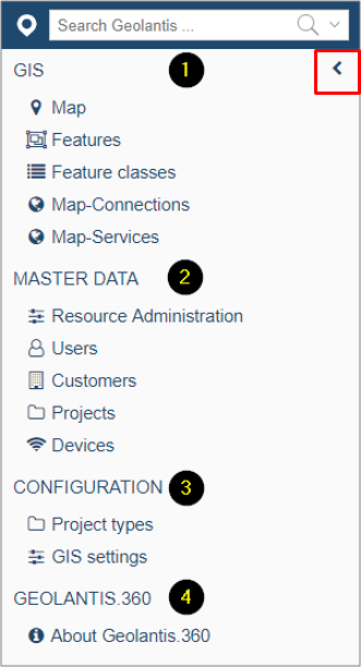
1. GIS section includes the following pages:
- Features: Map editor where features can be filtered, exported, created and edited
- Map connection: Establish WMS/WFS connections
- Map Service: Configure WMS/WFS project assignment
2. MASTER DATA section includes the following pages:
- Resources Administration: Manage company resources (organizational units)
- Users: Manage users & logins
- Customers: Manage customers info.
- Projects: Manage projects
- Devices: List of connected field devices
3. CONFIGURATION section includes the following pages:
- Project Types: Manage project types and define the scope of work
- GIS Setting: Define GPS tolerance for field mapping accuracy
4. Geolantis.360 section includes the following pages :
- About Geolantis.360: Includes the account name, download link for the mobile app, user manual, and useful links
The arrow at the top right can be used to hide/show the navigation panel when more space is needed.